Chapter 4
Lesson 3
This lesson examines:
- Airspace
Though many sUAS operations will occur in uncontrolled airspace, there are some that may need to operate in controlled airspace. Operations in Class B, Class C, or Class D airspace, or within the lateral boundaries of the surface area of Class E airspace designated for an airport, are not allowed unless that person has prior authorization from air traffic control (ATC). The link to the current authorization process can be found at www.faa.gov/uas/. The sUAS remote PIC must understand airspace classifications and requirements. Failure to do so would be in violation of the part 107 regulations and may potentially have an adverse safety effect. Although sUAS will not be subject to part 91, the equipage and communications requirements outlined in part 91 were designed to provide safety and efficiency in controlled airspace. Accordingly, while sUAS operating under part 107 are not subject to part 91, as a practical matter, ATC authorization or clearance may depend on operational parameters similar to those found in part 91. The FAA has the authority to approve or deny aircraft operations based on traffic density, controller workload, communication issues, or any other type of operations that could potentially impact the safe and expeditious flow of air traffic in that airspace. Those planning sUAS operations in controlled airspace are encouraged to contact the FAA as early as possible.
Temporary Flight Restrictions Certain temporary flight restrictions may be imposed by way of a Notice To Airman or (NOTAM). Therefore, it is necessary for the sUAS remote PIC to check for NOTAMs before each flight to determine if there are any applicable airspace restrictions here or here.
Small UA Operations Near an Airport - Notification and Permissions. Unless the flight is conducted within controlled airspace, no notification or authorization is necessary to operate at or near an airport. Operations in Class B, C, D and E airspace are allowed with the required ATC permission. When operating in the vicinity of an airport, the remote PIC must be aware of all traffic patterns and approach corridors to runways and landing areas. The remote PIC must avoid operating anywhere that the presence of the sUAS may interfere with operations at the airport, such as approach corridors, taxiways, runways, or helipads. Furthermore, the remote PIC must yield right-of-way to all other aircraft, including aircraft operating on the surface of the airport.
Remote PICs are prohibited from operating their small UA in a manner that interferes with operations and traffic patterns at airports, heliports, and seaplane bases. While a small UA must always yield right-of-way to a manned aircraft, a manned aircraft may alter its flightpath, delay its landing, or take off in order to avoid an sUAS that may present a potential conflict or otherwise affect the safe outcome of the flight.
For example: A UA hovering 200 feet above a runway may cause a manned aircraft holding short of the runway to delay takeoff, or a manned aircraft on the downwind leg of the pattern to delay landing. While the UA in this scenario would not pose an immediate traffic conflict to the aircraft on the downwind leg of the traffic pattern or to the aircraft intending to take off, nor would it violate the right-of-way provision of § 107.37(a), the small UA would have interfered with the operations of the traffic pattern at an airport.
In order to avoid interfering with operations in a traffic pattern, remote PICs should avoid operating in the traffic pattern or published approach corridors used by manned aircraft. When operational necessity requires the remote PIC to operate at an airport in uncontrolled airspace, the remote PIC should operate the small UA in such a way that the manned aircraft pilot does not need to alter his or her flightpath in the traffic pattern or on a published instrument approach in order to avoid a potential collision. Because remote PICs have an obligation to yield right-of-way to all other aircraft and avoid interfering in traffic pattern operations, the FAA expects that most remote PICs will avoid operating in the vicinity of airports because their aircraft generally do not require airport infrastructure, and the concentration of other aircraft increases in the vicinity of airports.
Type of Airspace It is important that sUAS remote PICs also be aware of the type of airspace in which they will be operating their small UA. Referring to the B4UFly app or a current aeronautical chart (http://faacharts.faa.gov/) of the intended operating area will aid the sUAS remote PIC’s decisionmaking regarding operations in the NAS
The two categories of airspace are: regulatory and nonregulatory. Within these two categories, there are four types: controlled, uncontrolled, special use, and other airspace. The categories and types of airspace are dictated by the complexity or density of aircraft movements, nature of the operations conducted within the airspace, the level of safety required, and national and public interest.
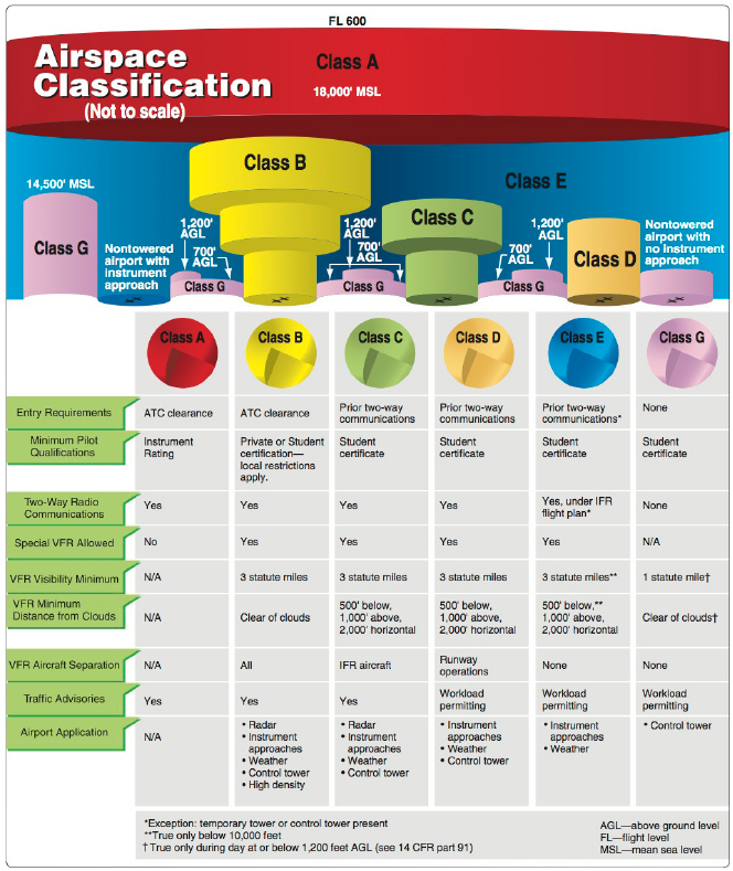
Controlled Airspace is a generic term that covers the different classifications of airspace and defined dimensionswithin which air traffic control (ATC) service is provided in accordance with the airspace classification. Controlled airspace consists of:
1. Class A. Generally, airspace from 18,000 feet mean sea level (MSL) up to and including flight level (FL) 600, including the airspace overlying the waters within 12 nautical miles (NM) of the coast of the 48 contiguous states and Alaska. Unless otherwise authorized, all pilots must operate their aircraft under instrument flight rules (IFR).
2. Class B. Generally, airspace from the surface to 10,000 feet MSL surrounding the nation’s busiest airports in terms of airport operations or passenger enplanements. The configuration of each Class B airspace area is individually tailored, consists of a surface area and two or more layers (some Class B airspace areas resemble upside-down wedding cakes), and is designed to contain all published instrument procedures once an aircraft enters the airspace. An air traffic control (ATC) clearance is required for all aircraft to operate in the area, and all aircraft that are so cleared receive separation services within the airspace. You can fly sUAS within it's boundaries without special permission if the ring indicates a floor above 400'.
3. Class C. Generally, airspace from the surface to 4,000 feet above the airport elevation (charted in MSL) surrounding those airports that have an operational control tower are serviced by a radar approach control and have a certain number of IFR operations or passenger enplanements. Although the configuration of each Class C area is individually tailored, the airspace usually consists of a surface area with a 5 NM radius, an outer circle with a 10 NM radius that extends from 1,200 feet to 4,000 feet above the airport elevation and an outer area. Each aircraft must establish two-way radio communications with the ATC facility providing air traffic services prior to entering the airspace and thereafter maintain those communications while within the airspace. You can fly sUAS within it's boundaries without special permission if the ring indicates a floor above 400' and you are 5 miles from the airport. If within 5 miles, you must obtain permission from the tower to fly.
4. Class D. Generally, airspace from the surface to 2,500 feet above the airport elevation (charted in MSL) surrounding those airports that have an operational control tower. The configuration of each Class D airspace area is individually tailored and, when instrument procedures are published, the airspace normally designed to contain the procedures. Arrival extensions for instrument approach procedures (IAPs) may be Class D or Class E airspace. Unless otherwise authorized, each aircraft must establish two-way radio communications with the ATC facility providing air traffic services prior to entering the airspace and thereafter maintain those communications while in the airspace.
5. Class E. Generally, if the airspace is not Class A, B, C, or D, and is controlled airspace, then it is Class E airspace. Class E airspace extends upward from either the surface or a designated altitude to the overlying or adjacent controlled airspace. When designated as a surface area, the airspace is configured to contain all instrument procedures. Also in this class are federal airways, airspace beginning at either 700 or 1,200 feet above ground level (AGL) used to transition to and from the terminal or en route environment, and en route domestic and offshore airspace areas designated below 18,000 feet MSL. Unless designated at a lower altitude, Class E airspace begins at 14,500 MSL over the United States, including that airspace overlying the waters within 12 NM of the coast of the 48 contiguous states and Alaska, up to but not including 18,000 feet MSL, and the airspace above FL 600.
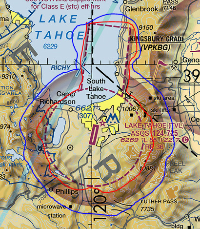
Class E almost always has one of four lower limits: those being surface, 700' AGL, 1200' AGL, or 14,500' MSL. Most of the country has a Class E lower limit of 1200' AGL. Where it drops to 700' AGL it is shown by a broad magenta line with a fuzzy side. The fuzzy side is the side where the floor of Class E is 700' AGL. The floor may also drop to the surface where it is called "Class E Surface Area". A dashed magenta line indicates the boundary of the Class E Surface Area. So on the image below, you can see the dashed magenta line (highlighted by red pen) around the airport indicating the outer boundary of the Class E Surface Area and outside of that a meandering wide magenta line (highlighted by blue) showing where the floor of Class E goes from 700' agl to 1200' agl as you go away from the airport. If the airport is only surrounded by the "meandering wide magenta line" than you can fly a sUAS within it's boundaries if you get permission from the tower, if it exists.
Uncontrolled Airspace or Class G airspace is the portion of the airspace that has not been designated as Class A, B, C, D, or E. It is therefore designated uncontrolled airspace. Class G airspace extends from the surface to the base of the overlying Class E airspace 1.Class G. Airspace not designated as Class A, B, C, D, or E. Class G airspace is essentially uncontrolled by ATC except when associated with a temporary control tower.
sUAS will always fly in class G airspace unless authorized by the tower prior to flight -or- the floor of the airspace is above 400 feet AGL. When flown within 5 miles of an airport, the operator of the aircraft will obtain permission from the airport operator and the airport air traffic control tower (when an air traffic facility is located at the airport) prior to the operation.
Special use airspace is the designation for airspace in which certain activities must be confined or where limitations may be imposed on aircraft operations that are not part of those activities. Certain special use airspace areas can create limitations on the mixed use of airspace. The special use airspace depicted on instrument charts includes the area name or number, effective altitude, time and weather conditions of operation, the controlling agency, and the chart panel location. On National Aeronautical Navigation Products (AeroNav Products) en route charts, this information is available on one of the end panels.
Prohibited areas contain airspace of defined dimensions within which the flight of aircraft is prohibited. Such areas are established for security or other reasons associated with the national welfare. These areas are published in the Federal Register and are depicted on aeronautical charts. The area is charted as a “P” followed by a number (e.g., “P-123”).
Restricted areas are areas where operations are hazardous to nonparticipating aircraft and contain airspace within which the flight of aircraft, while not wholly prohibited, is subject to restrictions. Activities within these areas must be confined because of their nature, or limitations may be imposed upon aircraft operations that are not a part of those activities, or both. Restricted areas denote the existence of unusual, often invisible,
hazards to aircraft (e.g., artillery firing, aerial gunnery, or guided missiles). IFR flights may be authorized to transit the
airspace and are routed accordingly. Penetration of restricted areas without authorization from the using or controlling agency may be extremely hazardous to the aircraft and its occupants.
Warning areas are similar in nature to restricted areas; however, the U.S. Government does not have sole jurisdiction over the airspace. A warning area is airspace of defined dimensions, extending from 12 NM outward from the coast of the United States, containing activity that may be hazardous to nonparticipating aircraft. The purpose of such areas is to warn nonparticipating pilots of the potential danger. A warning area may be located over domestic or international waters or both. The airspace is designated with a “W” followed by a number (e.g., “W-123”).
Military operations areas (MOAs) consist of airspace with defined vertical and lateral limits established for the purpose of separating certain military training activities from IFR traffic. Whenever an MOA is being used, nonparticipating IFR traffic may be cleared through an MOA if IFR separation can be provided by ATC. Otherwise, ATC will reroute or restrict nonparticipating IFR traffic. MOAs are depicted on sectional, VFR terminal area, and en route low altitude charts and are not numbered (e.g., “Boardman MOA”).
Alert areas are depicted on aeronautical charts with an “A” followed by a number (e.g., “A-123”) to inform nonparticipating pilots of areas that may contain a high volume of pilot training or an unusual type of aerial activity. Pilots should exercise caution in alert areas. All activity within an alert area shall be conducted in accordance with regulations, without waiver, and pilots of participating aircraft, as well as pilots transiting the area, shall be equally responsible for collision avoidance.
Military Training Routes (MTRs) are routes used by military aircraft to maintain proficiency in tactical flying. These routes are usually established below 10,000 feet MSL for operations at speeds in excess of 250 knots. Some route segments may be defined at higher altitudes for purposes of route continuity. Routes are identified as IFR (IR) and VFR A-711CONCENTRATED STUDENT HELICOPTER TRAININGALERT AREAS
(VR) followed by a number. MTRs with no segment above 1,500 feet AGL are identified by four number characters (e.g., IR1206, VR1207). MTRs that include one or more segments above 1,500 feet AGL are identified by three number characters (e.g., IR206, VR207). IFR low altitude en route charts depict all IR routes and all VR routes that accommodate operations above 1,500 feet AGL. IR routes are conducted in accordance with IFR regardless of weather conditions.
Temporary flight restrictions (TFRs) are put into effect when traffic in the airspace would endanger or hamper air or ground activities in the designated area. For example, a forest fire, chemical accident, flood, or disaster-relief effort could warrant a TFR, which would be issued as a Notice to Airmen (NOTAM).
National Security Areas (NSAs) consist of airspace with defined vertical and lateral dimensions established at locations where there is a requirement for increased security and safety of ground facilities. Flight in NSAs may be temporarily prohibited by regulation under the provisions of Title 14 of the Code of Federal Regulations (14 CFR) part 99 and prohibitions will be disseminated via NOTAM.
Download this app BeforeYouFly as it does all the work for you.
This lesson examined airspace.
In summary, know what airspace you are flying in.
The next portion is review of this course.
Practice Questions
1. What airspace can I fly in without tower permission?
Class DClass E
Class G
2. How close to an airport can I fly a sUAS without permission?
1 mile3 miles
5 miles
Review