Chapter 4
Lesson 1
This lesson examines:
- Weather effects
- Forecasts
Weather is an important factor that influences aircraft performance and flying safety. It is the state of the atmosphere at a given time and place with respect to variables, such as temperature (heat or cold), moisture (wetness or dryness), wind velocity (calm or storm), visibility (clearness or cloudiness), and barometric pressure (high or low). The term “weather” can also apply to adverse or destructive atmospheric conditions, such as high winds.
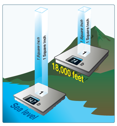
The unequal heating of the Earth’s surface causes changes in air pressure or the force exerted by the weight of air molecules. Although air molecules are invisible, they still have weight and take up space. Imagine a sealed column of air that has a footprint of one square inch and is 350 miles high. It would take 14.7 pounds of effort to lift that column. This represents the air’s weight; if the column is shortened, the pressure exerted at the bottom (and its weight) would be less. The weight of the shortened column of air at 18,000 feet is approximately 7.4 pounds; almost 50 percent that at sea level. For instance, if a bathroom scale (calibrated for sea level) were raised to 18,000 feet, the column of air weighing 14.7 pounds at sea level would be 18,000 feet shorter and would weigh approximately 7.3 pounds (50 percent) less than at sea level. The actual pressure at a given place and time differs with altitude, temperature, and density of the air. These conditions also affect aircraft performance, especially with regard to takeoff, rate of climb, and landings.
Atmospheric pressure is measured in inches of mercury (Hg) by a mercurial barometer. The barometer measures the height of a column of mercury inside a glass tube. A section of the mercury is exposed to the pressure of the atmosphere, which exerts a force on the mercury. An increase in pressure forces the mercury to rise inside the tube. When the pressure drops, mercury drains out of the tube decreasing the height of the column.
Since weather stations are located around the globe, all local barometric pressure readings are converted to a sea level pressure to provide a standard for records and reports. To achieve this, each station converts its barometric pressure by adding approximately 1 Hg for every 1,000 feet of elevation.

By tracking barometric pressure trends across a large area, weather forecasters can more accurately predict movement of pressure systems and the associated weather. For example, tracking a pattern of rising pressure at a single weather station generally indicates the approach of fair weather. Conversely, decreasing or rapidly falling pressure usually indicates approaching bad weather and, possibly, severe storms.
As altitude increases, atmospheric pressure decreases. As pressure decreases, the air becomes less dense or thinner. This is the equivalent of being at a higher altitude and is referred to as density altitude. As pressure decreases, density altitude increases and has a pronounced effect on aircraft performance. Differences in air density caused by changes in temperature result in a change in pressure. This, in turn, creates motion in the atmosphere, both vertically and horizontally, in the form of currents and wind. The atmosphere is almost constantly in motion as it strives to reach equilibrium.
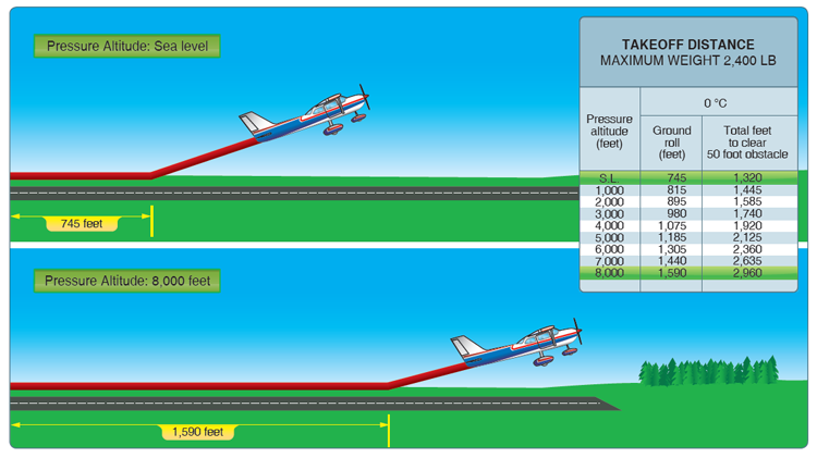
Altitude affects every aspect of flight from aircraft performance to human performance. At higher altitudes, with a decreased atmospheric pressure, takeoff and landing distances are increased, while climb rates decrease. When an aircraft takes off, lift is created by the flow of air around the wings. If the air is thin, more speed is required to obtain enough lift for takeoff; therefore, the ground run is longer. An aircraft that requires 745 feet of ground run at sea level requires more than double that at a pressure altitude of 8,000 feet. It is also true that at higher altitudes, due to the decreased density of the air, aircraft engines and propellers are less efficient. This leads to reduced rates of climb and a greater ground run for obstacle clearance.
Air flows from areas of high pressure into areas of low pressure because air always seeks out lower pressure. The combination of atmospheric pressure differences, friction, and temperature differences of the air near the earth cause two kinds of atmospheric motion: convective currents (upward and downward motion) and wind (horizontal motion). Currents and winds are important as they affect takeoff, landing, and cruise flight operations. Most importantly, currents and winds or atmospheric circulation cause weather changes.
High-pressure systems are generally areas of dry, descending air. Good weather is typically associated with high-pressure systems for this reason. Conversely, air flows into a low pressure area to replace rising air. This air usually brings increasing cloudiness and precipitation. Thus, bad weather is commonly associated with areas of low pressure.
Convective Currents - Plowed ground, rocks, sand, and barren land absorb solar energy quickly and can therefore give off a large amount of heat; whereas, water, trees, and other areas of vegetation tend to more slowly absorb heat and give off heat. The resulting uneven heating of the air creates small areas of local circulation called convective currents. Convective currents cause the bumpy, turbulent air sometimes experienced when flying at lower altitudes during warmer weather. On a low-altitude flight over varying surfaces, updrafts are likely to occur over pavement or barren places, and downdrafts often occur over water or expansive areas of vegetation like a group of trees. Typically, these turbulent conditions can be avoided by flying at higher altitudes, even above cumulus cloud layers.
Convective currents are particularly noticeable in areas with a land mass directly adjacent to a large body of water, such as an ocean, large lake, or other appreciable area of water. During the day, land heats faster than water, so the air over the land becomes warmer and less dense. It rises and is replaced by cooler, denser air flowing in from over the water. This causes an onshore wind called a sea breeze. Conversely, at night land cools faster than water, as does the corresponding air. In this case, the warmer air over the water rises and is replaced by the cooler, denser air from the land, creating an offshore wind called a land breeze. This reverses the local wind circulation pattern. Convective currents can occur anywhere there is an uneven heating of the Earth’s surface.
Convective currents close to the ground can affect a pilot’s ability to control the aircraft. For example, on final approach, the rising air from terrain devoid of vegetation sometimes produces a ballooning effect that can cause a pilot to overshoot the intended landing spot. On the other hand, an approach over a large body of water or an area of thick vegetation tends to create a sinking effect that can cause an unwary pilot to land short of the intended landing spot.
Effect of Obstructions on Wind - Another atmospheric hazard exists that can create problems for pilots. Obstructions on the ground affect the flow of wind and can be an unseen danger. Ground topography and large buildings can break up the flow of the wind and create wind gusts that change rapidly in direction and speed. These obstructions range from man-made structures, like hangars, to large natural obstructions, such as mountains, bluffs, or canyons. It is especially important to be vigilant when flying in or out of airports that have large buildings or natural obstructions located near the runway.
The intensity of the turbulence associated with ground obstructions depends on the size of the obstacle and the primary velocity of the wind. This can affect the takeoff and landing performance of any aircraft and can present a very serious hazard.
This same condition is even more noticeable when flying in mountainous regions. While the wind flows smoothly up the windward side of the mountain and the upward currents help to carry an aircraft over the peak of the mountain, the wind on the leeward side does not act in a similar manner. As the air flows down the leeward side of the mountain, the air follows the contour of the terrain and is increasingly turbulent. This tends to push an aircraft into the side of a mountain. The stronger the wind, the greater the downward pressure and turbulence become. Due to the effect terrain has on the wind in valleys or canyons, downdrafts can be severe.
Low-Level Wind Shear - Wind shear is a sudden, drastic change in wind speed and/or direction over a very small area. Wind shear can subject an aircraft to violent updrafts and downdrafts, as well as abrupt changes to the horizontal movement of the aircraft. While wind shear can occur at any altitude, low-level wind shear is especially hazardous due to the proximity of an aircraft to the ground.
Wind shear is dangerous to an aircraft. It can rapidly change the performance of the aircraft and disrupt the normal flight attitude. For example, a tailwind quickly changing to a headwind causes an increase in airspeed and performance. Conversely, a headwind changing to a tailwind causes a decrease in airspeed and performance. In either case, a pilot must be prepared to react immediately to these changes to maintain control of the aircraft.
It is important to remember that wind shear can affect any flight and any pilot at any altitude. Wind shear is a silent danger to aviation. Always be alert to the possibility of wind shear, especially when flying in and around thunderstorms and frontal systems.
Inversion - As air rises and expands in the atmosphere, the temperature decreases. There is an atmospheric anomaly that can occur; however, that changes this typical pattern of atmospheric behavior. When the temperature of the air rises with altitude, a temperature inversion exists. Inversion layers are commonly shallow layers of smooth, stable air close to the ground. The temperature of the air increases with altitude to a certain point, which is the top of the inversion. The air at the top of the layer acts as a lid, keeping weather and pollutants trapped below. If the relative humidity of the air is high, it can contribute to the formation of clouds, fog, haze, or smoke resulting in diminished visibility in the inversion layer.
Surface-based temperature inversions occur on clear, cool nights when the air close to the ground is cooled by the lowering temperature of the ground. The air within a few hundred feet of the surface becomes cooler than the air above it. Frontal inversions occur when warm air spreads over a layer of cooler air, or cooler air is forced under a layer of warmer air.
Ceiling - For aviation purposes, a ceiling is the lowest layer of clouds reported as being broken or overcast, or the vertical visibility into an obscuration like fog or haze.
sUAV's must remain 500 feet below and 2,000 feet away (horizontally) from clouds.
Visibility - Closely related to cloud cover and reported ceilings is visibility information. Visibility refers to the greatest horizontal distance at which prominent objects can be viewed with the naked eye.
sUAV's can only operate if there is at least 3 miles of visibility.
Aviation Routine Weather Report (METAR) - A METAR is an observation of current surface weather reported in a standard international format. While the METAR code has been adopted worldwide, each country is allowed to make modifications to the code. Normally, these differences are minor but necessary to accommodate local procedures or particular units of measure. This discussion of METAR covers elements used in the United States.
METARs are issued on a regularly scheduled basis unless significant weather changes have occurred. A special METAR (SPECI) can be issued at any time between routine METAR reports.
Example:
METAR KGGG 161753Z AUTO 14021G26KT 3/4SM +TSRA BR BKN008 OVC012CB 18/17 A2970 RMK PRESFR
Explanation:
Routine METAR for Gregg County Airport for the 16th day of the month at 1753Z automated source. Winds are 140 at 21 knots gusting to 26. Visibility is ¾ statute mile. Thunderstorms with heavy rain and mist. Ceiling is broken at 800 feet, overcast at 1,200 feet with cumulonimbus clouds. Temperature 18 °C and dew point 17 °C. Barometric pressure is 29.70 Hg and falling rapidly.
A typical METAR report contains the following information in sequential order:
- Type of report—there are two types of METAR reports. The first is the routine METAR report that is transmitted on a regular time interval. The second is the aviation selected SPECI. This is a special report that can be given at any time to update the METAR for rapidly changing weather conditions, aircraft mishaps, or other critical information.
- Station identifier—a four-letter code as established by the International Civil Aviation Organization (ICAO). In the 48 contiguous states, a unique three-letter identifier is preceded by the letter “K.” For example, Gregg County Airport in Longview, Texas, is identified by the letters “KGGG,” K being the country designation and GGG being the airport identifier. In other regions of the world, including Alaska and Hawaii, the first two letters of the four-letter ICAO identifier indicate the region, country, or state. Alaska identifiers always begin with the letters “PA” and Hawaii identifiers always begin with the letters “PH.” Station identifiers can be found by calling the FSS, a NWS office, or by searching various websites such as DUATS and NOAA's Aviation Weather Aviation Digital Data Services (ADDS).
- Date and time of report—depicted in a six-digit group (161753Z). The first two digits are the date. The last four digits are the time of the METAR/SPECI, which is always given in coordinated universal time (UTC). A “Z” is appended to the end of the time to denote the time is given in Zulu time (UTC) as opposed to local time.
- Modifier—denotes that the METAR/SPECI came from an automated source or that the report was corrected. If the notation “AUTO” is listed in the METAR/SPECI, the report came from an automated source. It also lists “AO1” (for no precipitation discriminator) or “AO2” (with precipitation discriminator) in the “Remarks” section to indicate the type of precipitation sensors employed at the automated station.
When the modifier “COR” is used, it identifies a corrected report sent out to replace an earlier report that contained an error (for example: METAR KGGG 161753Z COR).
- Wind—reported with five digits (14021KT) unless the speed is greater than 99 knots, in which case the wind is reported with six digits. The first three digits indicate the direction the true wind is blowing from in tens of degrees. If the wind is variable, it is reported as “VRB.” The last two digits indicate the speed of the wind in knots unless the wind is greater than 99 knots, in which case it is indicated by three digits. If the winds are gusting, the letter “G” follows the wind speed (G26KT). After the letter “G,” the peak gust recorded is provided. If the wind direction varies more than 60° and the wind speed is greater than six knots, a separate group of numbers, separated by a “V,” will indicate the extremes of the wind directions.Wind direction uses true north.
- Visibility—the prevailing visibility (¾ SM) is reported in statute miles as denoted by the letters “SM.” It is reported in both miles and fractions of miles. At times, runway visual range (RVR) is reported following the prevailing visibility. RVR is the distance a pilot can see down the runway in a moving aircraft. When RVR is reported, it is shown with an R, then the runway number followed by a slant, then the visual range in feet. For example, when the RVR is reported as R17L/1400FT, it translates to a visual range of 1,400 feet on runway 17 left.
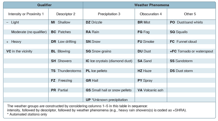
- Weather—can be broken down into two different categories: qualifiers and weather phenomenon (+TSRA BR). First, the qualifiers of intensity, proximity, and the descriptor of the weather are given. The intensity may be light (–), moderate (), or heavy (+). Proximity only depicts weather phenomena that are in the airport vicinity. The notation “VC” indicates a specific weather phenomenon is in the vicinity of five to ten miles from the airport. Descriptors are used to describe certain types of precipitation and obscurations. Weather phenomena may be reported as being precipitation, obscurations, and other phenomena, such as squalls or funnel clouds. Descriptions of weather phenomena as they begin or
end and hailstone size are also listed in the “Remarks”
sections of the report.
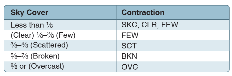
- Sky condition—always reported in the sequence of amount, height, and type or indefinite ceiling/height (vertical visibility) (BKN008 OVC012CB, VV003). The heights of the cloud bases are reported with a three-digit number in hundreds of feet AGL. Clouds above 12,000 feet are not detected or reported by an automated station. The types of clouds, specifically towering cumulus (TCU) or cumulonimbus (CB) clouds, are reported with their height. Contractions are used to describe the amount of cloud coverage and obscuring phenomena. The amount of sky coverage is reported in eighths of the sky from horizon to horizon.
- Temperature and dew point—the air temperature and dew point are always given in degrees Celsius (C) or (18/17). Temperatures below 0 °C are preceded by the letter “M” to indicate minus.
- Altimeter setting—reported as inches of mercury (Hg) in a four-digit number group (A2970). It is always preceded by the letter “A.” Rising or falling pressure may also be denoted in the “Remarks” sections as “PRESRR” or “PRESFR,” respectively.
- Zulu time—a term used in aviation for UTC, which places the entire world on one time standard.
- Remarks—the remarks section always begins with the letters “RMK.” Comments may or may not appear in this section of the METAR. The information contained in this section may include wind data, variable visibility, beginning and ending times of particular phenomenon, pressure information, and various other information deemed necessary. An example of a remark regarding weather phenomenon that does not fit in any other category would be: OCNL LTGICCG. This translates as occasional lightning in the clouds and from cloud to ground. Automated stations also use the remarks section to indicate the equipment needs maintenance.
This lesson examined weather and forecasts.
In summary, know the effects of weather and check the forecast.
You should now be able to read METARs.
The next lesson describes aeronautical maps.
Practice Questions
1. Atmospheric pressure is measured in?
Dew pointPounds per square inch.
Inches of mercury.
2. At what elivation are the clouds?
METAR KORD 041656Z 19020G26KT 6SM -SHRA BKN070 12/08 A3016 RMK AO270 feet
7,000 feet
700 feet
Next Chapter